Autumn 2002
The Olympic Peninsula
The Hoh Rain Forest
Hoquiam
The Coast
Mount St. Helens
Portland
Mount Ranier
Saturday, September 28 - The Coast
 We have been using the GPS while driving and it has been very handy. Yesterday it took it took us directly to Hoquiam Castle with no wrong turns. It does not work well in the rain forest though because it can't find enough clear sky to connect with the satellites. Every morning Richard sets our points using the computer and then we know when to turn.
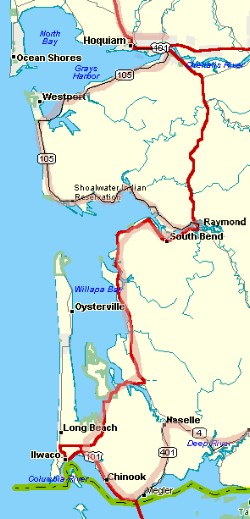
This morning after leaving the Castle we drove toward the ocean on SR 105 and drove along the coast from Westport to Raymond where we rejoined US 101. We saw numerous oyster farms with their huge piles of oyster shells. There were signs all along the highway stating that it was a Tsunami Evacuation Route. That is the first time we had seen a sign like that. In the Midwest there are often Snow Evacuation Routes, but no tsunami ones.
We had our first good view of the Columbia River near Chinook, Washington where we stopped for a snack at a small park along the river. This spot is historic, with the May 12, 1792 landing of Robert Gray and crew after entering the mouth of the river in his ship, the Columbia Rediviva, and naming the river after his ship.
This is also an encampment site of the Lewis and Clark expedition in November 1805. The weather exposure was so bad, though, that they moved over to the Oregon side to make their winter home at Fort Clatsop.
We left 101 at the north end of the Bridge to Astoria, Oregon and headed Northeast on SR 401 and then SR 4 to Longview, Washington. We spent the night in Kelso, planning a trip tomorrow to Mt. St. Helens.